Friday 21 December 2012

Solstice


Solstice is derived from two Latin words: "sol" meaning sun, and "sistere" to cause to stand still.


The Winter Solstice marks the first day of the season of winter. It falls on or near 21 December. In the southern hemisphere, the Winter solstice is celebrated in June when the northern hemisphere celebrates the Summer solstice

The Winter solstice is the time in December when the sun reaches its southern most latitude and therefore appear at its lowest in the sky at noon. The Winter solstice is the shortest day.

This is because the North Pole leans away from the sun. After the Winter solstice the Sun follows a higher and higher path through the sky each day until it is in the sky for exactly 12 hours. This occurs on the Spring Equinox.

After the Spring Equinox, the Sun still continues to follow a higher and higher path through the sky, with the days growing longer and longer, until it reaches it highest point in the sky on the Summer Solstice.


Tuesday 18 December 2012

First Aid Training - covered CPR, how to deal with choking and wound dressing

I went to Thirsk for a Yorkshire Ambulance Turst training session. Although an ambulance call out delayed me (!) - Huby had a major incident so I had to get around the Leeds ring road I was only a little late.

I learnt and practised (on the mannequins!) CPR or CardioPulmonary Resuscitation, which is a first aid technique that is used if someone is not breathing properly or if their heart has stopped. The real reason for doing it is simply that chest compressions and rescue breaths keep blood and oxygen circulating in the body.

If someone is not breathing normally and is not moving or responding to you after an accident,

1. Check the area for hazards - electricity, falling debris or structures, slips, etc. Is it safe for you?

2. If safe get to the casualty - if possible - from the feet first so they are not suprised if conscious. Get down to them and reassure them by holding their shoulders and speaking to them clearly in both ears (in case one doesn't work!).

3. With little or no response if someone else id around call for them to help and

4. Tell them to call 999 for an ambulance. When you call for an ambulance, telephone systems now exist that can give basic life-saving instructions, including advice on CPR. These are now common and are easily accessible with mobile phones.

5. Tell them to tell the ambulance dispatcher that the person is not responding and that CPR is being administered ...

IF THERE IS NO ONE ELSE CALL 999 BEFORE DOING ANYTHING ELSE ... UNLESS THE CASUALTY IS SMALL ENOUGH TO CARRY _ then do 5 rescue breaths and administer CPR for a minute ... then carry them with you to dial 999.

6. start CPR straight away. Hands-only compression if there is any doubt given the high risk of mouth-to-mouth contamination. NOTE: The gold standard still is 30-2 CPR Mouth-To-Mouth.

7. To carry out a chest compression:

Place the heel of your hand on the breastbone at the centre of the person’s chest.

Place your other hand on top of your first hand and interlock your fingers.

Using your body weight (lock out your arms and lean over using your upper body) press straight down by 5–6cm on their chest. STAYING ALIVE is the right rhythm.

Repeat this until an ambulance arrives.

Try to give 100 chest compressions a minute.

CPR with rescue breaths

Adults

Place your hands on the centre of the person's chest and, with the heel of your hand, press down by 5–6cm at a steady rate, slightly faster than one compression a second.

After every 30 chest compressions, give two breaths but tilt the casualty's head gently and lift the chin up with two fingers. Pinch the person’s nose. Seal your mouth over their mouth and blow steadily and firmly into their mouth. Check that their chest rises. Give two rescue breaths, each over one second.

Continue with cycles of 30 chest compressions and two rescue breaths until they begin to recover or emergency help arrives.

Children over one year old


Open their airway by placing one hand on the child’s forehead and gently tilting their head back and lifting the chin.

Remove any visible obstructions from the mouth and nose.

Pinch their nose. Seal your mouth over their mouth and blow steadily and firmly into their mouth, checking that their chest rises. Give five initial rescue breaths. SAME FOR POSSIBLE DROWNING:

Place your hands on the centre of their chest and, with the heel of your hand, press down by one-third of the depth of the chest using one or two hands.

After every 30 chest compressions at a steady rate (slightly faster than one compression a second), give two breaths.

Continue with cycles of 30 chest compressions and two rescue breaths until they begin to recover or emergency help arrives.

Babies under one year old

Open the baby's airway by placing one hand on their forehead and gently tilting the head back and lifting the chin.

Remove any visible obstructions from the mouth and nose.

Place your mouth over the mouth and nose of the infant and blow steadily and firmly into their mouth, checking that their chest rises. Give five initial rescue breaths.

Place two fingers in the middle of the chest (or hands around the trunk leaving the two thumbs over the sternum to press) and press down by one-third of the depth of the chest. After 30 chest compressions at a steady rate (slightly faster than one compression a second), give two breaths.

Continue with cycles of 30 chest compressions and two rescue breaths until they begin to recover or emergency help arrives.

Choking:

Clearing a blocked airway in conscious adults and children over the age of one follows; it is not meant to be used for choking infants under age one. See later

First, ask the person if he/she can speak. If he/she can speak, it means he/she still has good air exchange and might be able to get the object out of his/her throat on their own with some coughing. Ask them to try to cough the object out.

If the person can’t speak, makes high-pitched sounds when he/she talks or coughs, or it looks like their not breathing, it’s time to intervene.

If the casualty is conscious and choking .... the first is to slap them - quite hard - on the back 5 times - between the shoulder blades - with the casualty leaning forward but supported (so they cannot fall!). Warn them!

If this fails then - with them still leaning forward but supported by your arms - stand behind them and hold them in your two arms do that your hands interlock and one of the thumb joints is at a sharp angle inwards towards the casualty. A fist width with the thumb bent locates the right part of the diaphragm to thrust into.

The act of abdominal thrust lifts the diaphragm and forces air from the lungs, similar to a coughing action, so that the foreign body in an airway may be moved and expelled.

Stand behind the person, wrap your arms around the waist, and tip the person slightly forward.

Make a fist with one hand and place it slightly above the navel.

Grasp your fist with your other hand and press forcefully into the abdomen with quick, upward thrusts, using force as if you were attempting to lift the person up.

Continue the back slaps / thrusts - 5 each - until the foreign body is dislodged OR if the casualty loses consciousness go to CPR. When a choking person is unconscious, lower the person on her back onto the floor. Clear the airway using the head-tilt method. If you can see the blockage, reach a finger into the mouth and sweep it out (finger sweep), using caution not to push the object deeper into the airway. If you are unable to remove the obstructing object and the person doesn't respond, you must begin CPR. In this case, there is a chance that the chest compressions used in CPR will free the object so recheck the mouth at regular intervals.

To clear an airway obstruction of a pregnant woman or obese person, place your fists closer to the chest, right above the joining of the ribs at the base of the breastbone, and follow chest thrusts.

In the case of a choking infant younger than age one, sit with the infant face down on your forearm, positioned securely on your thigh. Thump the infant firmly and gently five times with the heel of your hand in the middle of the back. The back blows and the gravity will most likely free the obstruction.

If it doesn't work, turn the infant face up on your forearm, head lower than body, and use two fingers positioned over the center of the breastbone just below the nipples and give five quick chest compressions. Continue to repeat the back blows and chest thrusts and if the infant doesn't start breathing, call 999.

If you have cleared the obstruction and the infant doesn't start breathing, begin CPR.


Sunday 9 September 2012

2012 - Third trip - Out up the Sound of Mull and into Loch Sunart


Sunday 2nd September: Richard and I travelled up to Oban from 11am - roughly! Passed the mouth of Loch Etive and the Connel Bridge and stooped to view the impressive Falls Of Lora. (The falls are generated when the tide level in the Firth of Lorn drops below the level of the water in Loch Etive. On the Ebb tide, the seawater in Loch Etive pours out through the narrows).


Got to Dunstaffnage at around 6pm and loaded the boat & ate at 'The Wide Mouthed Frog'.

Monday 3rd September: Sailed up The Sound Of Mull. We set off about 1pm - on the engine until we had past the fish farm south of Ardmucknish/Dunstaffnage Bay - then we sailed with a reef - the second one - on the mainsail and creamed up the Sound of Mull.


The weather was OK and we enjoyed the beam reach with strong winds. I got a mooring by ringing the relief pontoon manager at Tobermory. We reached Calve Island and turned in and by then we were in heavy rain. By the time we had moored up - quite close in - we were thoroughly wet, so we ate in 'Macgochans' - the nearest place to the pontoons. It was v. average.


Tuesday 4th September: I looked around Tobermory and bought some milk from the Coop. We set sail, motoring out of Tobermory and headed north up the Sound. We had the sail up pretty quickly and had a good sail heading Northwestwards. Then we turned east for Loch Sunart - a sea loch that runs east from the sea, bounded to the north by the Sunart district of Ardnamurchan.


We passed Glenborrodale Castle and Mingary Castle ruins as well as Ben Hiant. Ben Laga and Ben Resipole can be clearly seen. At 19 miles long it is one of the longest sea lochs in the Highlands with a maximum depth of the loch over 120 metres (East of Càrna and the entrance to Loch Teacuis). Islands in the loch include Oronsay, seaward of Càrna, Risga, which lies between the two larger islands, and Eilean Mòr, which lies towards the landward end of the loch in line with Beinn Resipol. We sailed past Salen Bay and headed up the loch.


We spent about an hour sailing up towards Salen Jetty. This is situated within Salen Bay on the north shore of Loch Sunart on the Ardnamurchan Peninsula. We had a meal at the Salen Hotel and afterwards Tom (Colville) joined us - Richard had called him as we relaxed at the Pier - he lives locally and enjoyed a couple of coffees as I listened to then reminisce about Drascombes.

Wednesday 5th September: We set off from the Pier at around 09:30 and motored out of the Loch. We put the sails up before we left the loch - just on the land side of the tidal island of Eilean Mor - and then turned down the Sound after we cleared Oronsay - a uninhabited, low-lying, barren and rocky, enclosing Loch Drumbuie.


We sailed down and then the wind dropped a bit. After Richard played around with the sails we got some good wind and had to gybe down the lower part of the Sound - using the engine at the latter stages and made it to Dunstaffnage - albeit late in the day - it was about 7 pm before we switched off and moored etc.

Thursday 5th September: The day dawned, with Cryptic on the pontoon at Dunstaffnage, wet and windy. More wind then rain but nevertheless not a pleasant start. I sorted a few things out while Richard had a shower etc. and got an up-to-date weather forecast. It looked grim so we decided to go home ... stopped off in Callander - at the Roman Camp Hotel - in 20 acres of gardens, on the banks of the River Teith, (salmon sea trout and brown trout!), a unique country house hotel.


Saturday 8 September 2012

2012 - Second trip

Monday 13th 2012: Got up to Oban (about six hours) and left the car at Dunstaffnage. Got a bus to Oban and waited for the ferry ride to Kerrera.


One of the ferries was broken down and had to be brought in by another one. Couldn’t get on that one – I was twelfth and he was only taking 12 (though on the way out last time he took 14!). Waited on the next – a relief vessel! Then got to the office too late – everyone had gone! So had to await the return of the ferry to ask if I could win back my keys. Got the wrong ones to start with but eventually got sorted and then rushed back to get the ferry so we could eat in Oban! Went to ‘Room 9’ and had an excellent sea bass. Got the ferry back and slept on board.

Tuesday 14th 2012: Left a disappointing Oban Marina – no car parking, poor ferry service and v. substandard. Dunstaffnage Bay is a sheltered inlet at the mouth of Loch Etive, Dunstaffnage Bay is located 2 miles (3 km) west of Connell, (near the Connell Bridge)


and 3 miles (5 km) northeast of Oban in Argyll and Bute. The settlement of Dunbeg, the Dunstaffnage Marine Laboratory and Dunstaffnage Castle all lie around its shores. The island of Eilean Mor lies at its entrance. Sailed to Dunstaffnage Marina where all seemed excellent in comparison to Oban. Got messed about a bit on berthing but all ended well – especially when I got a power cable extension. We explored the castle after trying out the new outboard and tender. (A bit embarrassing – we ran out of petrol on the beach near Dunstaffnage Castle!). After drying out etc. we ate at ‘The Wide Mouthed Frog’.


Wednesday 15th 2012: Tried to sail north up Loch Linnhe (known in Gaelic as An Linne Dhubh upstream of Corran - and known as An Linne Sheileach downstream of Corran). It’s a sea loch just around the corner (turn right after the two headlands of the western edge of the mainland in Ardmucknish Bay) – out from Dunstaffnage Marina.


Loch Linnhe is about 30 miles long and opens out from the Firth of Lorne (South West edge) past the large island of Lismore - a part known as the Lynn of Lorne. Loch Eil feeds into Loch Linnhe at the Northernmost point, while from the east Loch Leven feeds in the loch just downstream of Corran and Loch Creran feeds into the Lynn of Lorne. The town of Fort William lies at the northeast end of the loch, at the mouth of the River Lochy.

A few ferries operate hereabouts – one from Oban to Achnacroish on the Island of Lismore. Another to reach Lismore is the Corran Ferry (one of few remaining mainland vehicle ferries in Scotland), which operates across the Corran Narrows, (it is about nine miles south of Fort William).


Nowadays there are about 150 people living on Lismore – one of the most fertile islands of Scotland, (especially considering the presence of Dalradian Limestone over almost all over the island!).


Probably due to it's fertility the island once supported a much larger population. By the start of 19th Century the island was inhabited by 900 people, half a century later around 1,400 and then population numbers gradually declined to its current level of around 150.

We motored up the loch, watching a yacht come flying by … (as Stan said then “at a rate of knots!”). All sail out in quite high winds – gusting to low 20s. We thought they had too much canvas out and were heeling quite a bit.


A second boat behind seemed more circumspect and tacked quite a bit … but still caught us up. He went into Linnhe Marine - situated in Dallens Bay - sheltered by Shuna Island.


We passed the Northern end of Lismore, (heading to port would have taken us to Port Ramsay) and Port Appin on our starboard side. (We had passed by then the Port Appin North buoy – fairly close at hand too).


By then we figured it would be wise to turn around and so we headed back. After berthing we went to Oban to Tesco’s for supplies and then ate a splendid supper of steak etc. that Stan made for us.

Thursday 16th 2012: Storm bound – quite high winds today so we did quite a few jobs around the boat including checking out the chutes, (cruising and spinnaker) and the storm jib. Photo below stolen from the Web to show Stan and I how a spinnaker should look on a Contessa! - From http://www.yachtsandyachting.com/news/17536/Contessa-32s-at-Hamble


I think we had an early dinner in ‘The Wide Mouthed Frog’ again and had an early bed.

Friday 17th 2012: Sailed down to Loch Linnhe again – and used the wind quite a bit this time! We passed the end of Lismore and this time head to port in to Port Ramsay (note the two ‘a’s), where we anchored and had lunch! It was serene … pretty poor visibility by then and still – both wind and waves.


Port Ramsay is a small village to the north of the Island of Lismore. It was built to house the workers of the limestone; lime was processed in lime kilns and then used for agriculture and in mortar for buildings. The village is situated on a sheltered bay guarded by a series of skerries and small isles.

We upped anchor and motored back … Later on in the day we motored into Oban in the car – to Waterstones, had a coffee and then ate at ‘Room 9’ (Pork Loin and Pancetta) again.


Saturday 18th 2012: Sailed out towards Mull which has a coastline of 300 miles! It’s climate is moderated by the Gulf Stream and it has a mountainous core - the highest peak on the island being Ben More at 3,169 feet! Radiating out were various peninsulas, which are predominantly moorland. Numerous islands lie off the west coast of Mull, including Erraid, Inch Kenneth, Iona and Ulva. Even smaller uninhabited islets include Eorsa, Gometra, Little Colonsay, as well as the Treshnish Isles and of course Staffa of Fingal's Cave fame. Calve Island is an uninhabited island in Tobermory Bay. Two outlying rock lighthouses are also visible from the south west of Mull, Dubh Artach and Skerryvore. The Torran Rocks are a large shoal of reefs, islets and skerries, approximately 15 square miles in area and are located two miles to the South West, between the Ross of Mull peninsula and Dubh Artach. During the Highland Clearances in the 18th and 19th centuries, the population fell from 10,000 to less than 3,000.) The Sound of Mull is a deep trench carved by retreating glaciation that separated Mull from mainland Scotland some twelve thousand years ago.


Stan’s idea was that we would have lunch at anchor, (allowing us to practice our technique!), in Loch Aline. We sailed into the Sound, with it’s Eastern entrance’s tidal gate which was fun … (West of here the tides are typically less than one knot). We saw the Oban to Craignure ferry (the CalMac) and stayed clear of her. We sailed quite near the former Royal Yacht ‘Bloodhound’*, which took the southern channel – which seemed less disturbed.

We sailed on up, (once we had sorted our sails out!), on past Duart Castle, the ancestral home of the Clan Maclean. The castle stands on a crag at the end of the peninsular jutting out into the Sound of Mull at the intersection of the sound of Mull, Loch Linne and the Firth of Lorne and within view of the neighbouring castles of Dunstaffnage, Dunollie, Aros and Ardtornish -part of a chain of castles up the Sound of Mull to Mingary Castle.


*The classic and elegant 1930s ocean racing yacht Bloodhound, owned by The Queen and Prince Philip in the 1960s, is now moored alongside The Royal Yacht Britannia in Edinburgh. Built in 1936 by the famous Camper & Nicholsons yard in Gosport, Bloodhound was one of the most successful ocean racing yachts ever built, winning scores of races in the south of England and also crossed the Atlantic to compete in Bermuda. On the back of this outstanding race history the Royal Family acquired Bloodhound in 1962 and Prince Philip had much success competing with her at the famous Cowes Week regatta around the Isle of Wight.


We anchored in the Scallastle Bay area, quite close to shore … in about 3 metres. I put about 25 metres of chain out with the anchor – more than enough! We had lunch and looked around – so peaceful and relaxing.


Reluctantly – as the sun was quite lovely by now – we packed in after an hour or so and headed back. We motored through the tidal gate, (though we kept the main up), and sailed across quite a bit of the Firth of Lorne.


We did a MOB when Stan lost his baseball cap but unfortunately the 'man' died – drowned probably as the cap soaked up water and drifted below a disturbed surface.


I realised Newcastle vs. Spurs was on ESPN and tried to ring Margaret, (didn’t get through but she had recorded it for me! … 2-1 to the bad guys too!). Ate fish & chips at ‘The Wide Mouthed Frog’.

Sunday 19th 2012: Drove home at 9:30. Got in about 3pm.

Sunday 29 July 2012

First summer 2012 voyage.


8th July - Set off with Stan from Maryport on Sunday night at about 18:05 BST on engine at about 6 knots. Bearing was 260 degrees, avoiding wind farm. At 20:00 we changed to 270 degrees – the wind was dead ahead at about 10 knots. We topped up the engine tank with fuel.


9th July – Bangor At 4:45 in the morning we were about 9 Nm due south of the Rhinns. We arrived at Belfast Lough at about 08:30 and moored up at Bangor


Latitude: 54° 40'N Longitude: 05° 40'W - at 10:00 after refueling tank and spare cans. Then, after settling the boat, we had a v. late breakfast in some place up the way and checked out some chandlers to get something to try to lock off the shackle of the mainsail that was missing. We failed, though I got some batteries for the torch (AAA). Then we cleaned up – boat and ourselves - and I did some laundry work. We ate early at a curry restaurant and slept. The marina was notable for the presence of the buttresses in the old North Pier nesting places for the Black Guillemots (back in the early 1900s a small population became established. Today the Black Guillemots nest not only in holes in the North Pier, but also in nest boxes and holes in the Central and South Piers - indeed the population of breeding birds now exceeds twenty-five pairs. The Black Guillemots occupy Bangor Marina for much of the year, except during August and September when they are moulting into winter plumage on the waters of Belfast Lough. By January most of the birds are moulting back to their brilliant summer plumage - jet black with a large wing patch.


Normally the female lays two eggs around the middle of May and for just over a month, the male and female birds are occupied incubating the eggs. This is followed by a frenzy of activity as parent birds fly in and out of the Marina carrying butterfish for their every-growing and demanding young. The young stay in the nest holes for five to six weeks, after which they too, leave to join the adults in Belfast Lough. The process of 'ringing' the birds has revealed that they return to breed from about four years of age, and may continue to breed for another ten years or more.

10th July – Set off for Glenarm (from Irish meaning "valley of the army"). The halyard black came adrift from the foot of the mast. We managed anyway with just an uncomfortable looking angle on the halyard through to the clutches. We left the mainsail up even when we had to motor. We reached Glenarm - which also had the Black Guillemots too - a harbour whose village is in County Antrim, on the North Channel coast - north of the town of Larne and south of the village of Carnlough with only 582 people.


It was 4 hours to here from Bangor - and involved passing the Isle of Muck, Antrim - where we proceeded to get very wet - thanks to the overfalls. The water came up over the stern and the spray-hood.


I had only closed the hatches on the first closing point, so we got the bedding etc. soaked too. We made Glenarm harbour at last - which has long been a port for sailors and yachtsmen travelling to and from Scotland's island-studded western coast – it has 40 berths within the village's historical limestone harbour - it was used mainly for the export of limestone from the nearby quarry – and Puffers were frequent visitors loading out limestone. Then the harbour became too small for modern shipping, becoming an eyesore after years of disuse - at one time it was used as a dump for bits of fallen cliff face after winter landslides on the coast road. It was re-built as a marina in the early part of this century. We paid etc. at the Marina HQ then went for a drink in town.

11th July – Campbeltown. Set off from Northern Ireland at about 10:00 and by 13:00 we were halfway at +55.0600 -05.4400 - well into the North Channel* (Sruth na Maoile as it is known in Gaelic - alternatively in English as the 'Straits of Moyle'.

**Note of historical interest - HMS Drake - a 14-gun sloop-of-war - fought a North Channel naval duel with the 18-gun sloop 'Ranger' of the Continental Navy (the early United States Navy), commanded by Captain John Paul Jones.


Five of Drake's crew, including her captain, George Burdon, were killed, and after an hour-long engagement, Drake surrendered to the Americans. Jones was able to evade capture and deliver Drake to Brest, France as his prize on 8 May 1778. This was the first, and most decisive, American victory over any Royal Navy vessel in British waters.


We sailed / motored here from Glenarm and on the way passed Ailsa Crag*. Must have sailed for about 4 to 5 hours and did about the same on the engine - getting in and out of harbours especially.


**Ailsa Craig is a volcanic plug of an extinct volcano and rises straight from the sea bed to about 1,110 feet (340m) abover sea level. Located about 10 miles west of Girvan and about 2 miles in circumference it dominates the skyline for much of the outer Firth of Clyde and an excellent reference point.

As we sailed/motored towards Campbeltown we saw ahead Arran ahead as we moved on ...


... then we came past Sanda Island ...


... then up past Daaver Island and arrive eventually in Campbeltown ... in Scottish Gaelic it is 'Ceann Loch Chille Chiarain' - a town and former royal burgh in Argyll and Bute. It lies by Campbeltown Loch on the Kintyre peninsula - it was renamed in the 17th century as Campbell's Town after Archibald Campbell (Earl of Argyle) was granted the site in 1667.


Davaar Island (in Scottish Gaelic 'Eilean Dà Bhàrr') is located at the mouth of Campbeltown Loch guarding the approach. A tidal island, it's linked to the mainland by a natural shingle causeway (called the Dhorlin apparently), visible at low tide - the crossing can be made in around 40 minutes approximately.

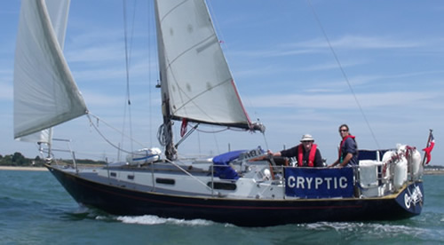
Campbeltown became an important centre for shipbuilding and Scotch whisky, and a busy fishing port. The town's remote location near the far end of a long peninsula makes for a difficult road journey, noted by Fiona as we paid at The Royal Hotel - "Glasgow is 136 miles away", she told us! We had rafted up at about 6pm, next to a couple who were from Northern Ireland. We strolled along Kinloch Road, popped into Tesco's, put away our shopping and went for a meal in the Harbourview Grille, in The Royal Hotel's grill - having had a drink first in the pub inside the hotel called "The Black Sheep Pub" (not brilliant!). We didn't refuel and set off at 0930 as our neighbours told us they pushing off then ... (they didn't!).

12th July – East Loch Tarbert next - took most of the day to get there sailing and motoring. We reached it at about 17:30. The place, which I thought was lovely, sits around a harbour in an attractive horseshoe shape - it's a natural amphitheatre surrounded by heather covered hills. We moored up on the pontoons and went ashore to pay and to find out where we might find a to replace the broken block that was meant to be securing the mainsail halyard at the base of the mast. No luck, so Stan used an old fisherman's trick (thanks Gilbert for the tip) of super-glueing the thread lightly and the block was refitted. We ate at The Anchorage restaurant. Sea Bream with lovely vegetables for main - lovely and we shared some prawns to start. Very good (met some Dutch guys who were cycling to Campbeltown - two of whom claimed to have sailed the Atlantic!).


The harbour is overlooked by the castle of Robert The Bruce keeping a watchful eye at this strategic position and looks out to Loch Fyne. The harbour seems to be the focal point of the village - with a small productive fishing fleet, facilities for sailing yachts an some pretty touristy shops and restaurants.


The village of Tarbert, as it seems to be known, lies at the eastern side of the Kintyre peninsula - it is a part of the much larger Loch Fyne. (East Loch Tarbert is separated from West Loch Tarbert by an isthmus only 1.5 kilometres long). Whilst walking around the harbour we noticed two skiffs - 'Iolair' (originally built in Port Bannatyne on the Isle of Bute) and 'Wee Dooker' (the local nickname for Guillemot). These are replicas of the clinker built timber boats propelled by oar and wind used on the West coast of Scotland since earliest times with boatbuilding methods and design showing a clear Norse influence. There are many variations but these fishing boats were generally double ended craft built of Larch and Oak with a Lug sail and in later years a jib and bowsprit. These boats had a distinctive underwater shape and steeply raking stern post. This became known as “The Loch Fyne Skiff” designed in the mid 1880s for a "new kind" of fishing - involving the use of two such vessels surrounding a whole shoal of herring and netting them.


All in all - a pretty place ... here's three more photos showing the place.


13th July – Largs. We set off - at 09:05 to be precise ... and shortly after clearing the harbour area we set sail. We were impressed with the view as we left ... and humbled by the lovely houses that had been built around this anchorage.


We sailed ... and tacked quite a few times .... as we moved down Loch Fyne ... until we came to the departure point ... wither we did the Kyles of Bute or continued down to the bottom edge (southern tip) of Bute and turned below Great Cumbrae and above Little Cumbrae. Stan suggested we practised mooring in Millport. Sounded good - especially as the Kyles' weather looked rainy and cloudy.


We successfully moored - twice - and then motored over to Largs. I had let Steve Cockerham know where I was and found to no surprise that he and Jenny with two friends - were heading to Largs for the weekend sailing in 'Wavecrest'. He was keen to come over and see 'the beast' (though his is a Sadler 34 ... so mine is smaller!). It happened that Richard turned up first and after introductions and settling him on board (Stan seemed keen to try the quarter-berth!) Steve, Jenny and friends came over to look 'Cryptic' over. They went for a drink and then were heading back to cook on board. Richard took us for a curry in Largs town.

14th July – We set off for Campbeltown (again!), dropping Stan off after breakfast and shopping in the local Largs supermarket. Wet motored out - around 12:30 and then after an hour Richard and I chose to sail down the eastern side of Arran until we got to just short of Holy Isle at around 15:00, when we put the engine on again. We switched off again north of Pladda Isle (it lies off the south east coast of Arran and the lighthouse has apparently two lights to distinguish it from the many other lighthouses in the area).


We sailed on quite quickly - with Richard helming - until around 19:20 (55deg 22min 05sec) when we realised we couldn't furl the genoa. I strapped on and went to try to free it. In spite of taking some of the line out of the furler and re-threading it I couldn't get it to work so reluctantly cut the job sheets as close to the bowlines tying them to the sail as I could.


I got a nasty cut on my forehead too ... luckily I only noticed after the job was done. I beat a hasty retreat to the cockpit and Richard gave me Stan;s towel (which was to hand) to try to staunch the blood. By now we were in a Force 6 and heading west into the sun, and I found it hard to keep on course. Richard was below and plotting well. By 20:40 we were off Daavar and heading into calming water where we could bring in the mainsail. The engine was still on and the jib flapping away uselessly but dangerously. We rafted at 21:40 (relatively gently - though I scratched the wood on the wooden fishing boat I was encouraged to moor up against), with a lot of help - mainly some visiting yachtsmen from the Midlands (retirees and spending a few months sailing W. Scotland from Wales in their centre cockpit Moody 35s. The owner of the fishing boat had seen us come and came down to tear me off a strip - which he proceeded to do until he realised I was cut and bleeding (and not really paying him any attention!)... Then bless him, he took me up (with his wife driving) to the Accident and Emergency Dept of the local hospital.


I got cleaned up an the cut was scabbing so the nurse left it and then checked my head for other injuries. There were none, so after tea and a shortbread I got a taxi back to find Richard had made pasta for himself. We turned in.

The next day dawned OK but most yachts were staying put as the weather out at sea was poor. After a wash etc. at the local 'Aqualibrium' (Swimming baths/Library!) I felt a lot better. Richard & I had breakfast in The Royal Hotel and then, as promised, the owner of the fishing boat came down to see how I was. He was fine about the small damage (scratch) I had made to his boat and then the Midlanders helped us sort out the furling gear and the genoa. Then later - at about 12 noon - we got called by one of them to look at the 'Waverley' that was coming in as part of its tour ... it docked on the fishing quay.


We had to wait its arrival but it was a warm, though windy afternoon. It came at last - the last sea-going paddle steamer in the world - built on the Clyde in 1947 to replace the original which was sunk at Dunkirk. She had a lot of brass on board and must have some powerful mighty engines! Big mooring warps too ... They were fed up to the quay from some lighter lines thrown ashore by the crew and wrestled on to the quayside bollards. She docked and was due to depart about 12:30 - cruising around the Mull of Kintyre and up to Oban. A route we were going to follow soon....


That evening we walked on a pleasant evening to the Ardshiel Hotel where we enjoyed a meal (in the Garden Restaurant - and Richard a malt whisky). The buildings on this side of Campbeltown seemed rather grand - apparently lots of whisky barons had homes here in the past!

15th July – A big day - the plan is to round the Mull of Kintyre and anchor up at Gigha in Ardminish Bay. Before we cast off and after I cleaned my teeth/washed etc. I filled up two diesel cans, (with road diesel), and I eventually bought some oil for a two stroke and a petrol can and filled up with fuel. Off we set about an hour later than planned - at 0930. At 11:20, motoring, we passed Latitude N 55 19.5 Longitude W 5 33.6 - 'Arranman's Barrels' - a group of small stacks to the NW of Oitir Mor - a rocky isle.


By 11:40 we were abeam Macharioch buoy and then Southend. To our South lay Sanda and Sheep Isle. We continued - in a flat calm - and passed some overfalls that in rougher weather would be fun!


We moved West gradually ... and then, at around 14:30 we now started to move North! We had rounded the Mull! It's worthy of note is that the Kintyre Peninsula extends about 40 miles south from the mainland and protects the Firth of Clyde from the Atlantic so this area is fairly sheltered. There is a large tidal difference between either side of the peninsula which causes strong tides around the Mull of Kintyre.


The name is an Anglicisation of the Gaelic Maol Chinn Tìre – or in English: "The rounded headland of Kintyre". The Mull is at the extreme southwestern tip of the Kintyre peninsula, approximately 10 miles from Campbeltown in Argyll and Bute, Western Scotland. At its closest point, mainland Northern Ireland is only 12 miles from the Mull. It is about 8 miles beyond the southernmost village of the peninsula, Southend. Ailsa Craig and the Antrim coast of Northern Ireland and Rathlin Island are all often clearly visible from the Mull though the area is often being plagued with sea-mists.. Notoriously strong currents plague the tip of the Kintyre Peninsula creating a hazard to sailing craft.

Gigha Island - lying 3 miles from the western peninsula of Kintyre. It is some 7 miles long and 1 mile wide with Ireland 30 miles south, Islay 10 miles west and Jura 10 miles north-west. The views are stunning with the Paps of Jura, Ben More 50 miles away on Mull, Goat Fell on Arran 20 miles away to the east - 55°39'N., 5°46'W. It's a hilly populated island lying 3 miles off the coast of Kintyre. Cara and Gigalum (55°38'N., 5°45'W.) are small islands lying off the S end of Gigha. All these islands are encircled by foul ground and above and below-water rocks and reefs. At Ardminish Bay (55°40'N., 5°44'W.), on the East side of Gigha, there is a pier and anchorage. We moored (successfully!) and got out the tender (an old .... old Avon Redstart), and, eventually having inflated it, put on the outboard. I practiced - narrowly managing not to sink after I hit the mooring buoy. Then Richard boarded and we managed to get to shore.


We left the tender and wandered off - after booking the Boat House for a dinner - to see the gardens - Achamore. These are situated within the Community-owned Isle of Gigha and the garden is Oceanic, Atlantic and is influenced by the Gulf Stream. Frosts are rare and snow even rarer.


Rainfall is reputed to be only 100cm in comparison to the mainland which can be double. The gardens originally were laid out for Rhododendrons and lay between 10 metres to 100 metres above sea-level. Fertile acid sandy loam with some clay and gravel subsoil. ideal growing conditions for a wide variety of plants from around the world including lower-order Bryophytes and Ferns.

We returned and had a dinner that was fine ... not brilliant, but OK. We returned to the slightly decompressed tender and managed to get her back to the yacht and carefully loaded her back on deck after taking off the outboard and stowing it. Note - must get a more reliable tender and a new outboard!


16th July – Set off at 11:30 for Craobh Haven - we switched the engine off at 12:35 and had to put it back on at 13:00 - wind was tiny and anyway against us. We steadily motored up past the East coast of Jura in a poor visibility and past Loch Sween and then Loch Craignish. We continued up past the Northern edge of Jura - past a weak Gulf of Corryvreckan and then past Scarba noting the Small Isles abeam ... ahead, to starboard was the entrance to Loch Coalisport - then there is the MacCormaig Isles.
To starboard the entrance to Loch Crinan and the Dorus Mor. Heading up Loch Shuna leaving Scarba Luing and Shuna to port and Eilean Arsa to starboard. Then there is the sheltered entrance to Craobh Marina.


It was wet by now - raining ... and after mooring up we went for a meal at 'The Lord Of The Isles' pub.

17th July – In the morning left at 11:30 bound for Kerrera Island, Oban. We first rounded the South side of the first Isle in front of Luing - one of the Slate Islands - home of the "Grey Dog" tidal race, which runs in the sea channel to the south, and reaches 8 knots in full flood. ... then North of Luing itself into the Cuan Sound.


Thanks to Richard's pilotage we moved through a difficult passage - the tidal gates - with some ease, though it was neaps and calm. Still, just before we broke out of the passage we got rough waters and hit considerable waves as we moved out into the Firth of Lorne.

We passed the islands of Easdale and Luing and looked back to see the whereabouts the ‘Bridge over the Atlantic’.


We got overtaken by a CalMac ferry - between Colonsay and Oban - then we entered the Sound Of Kerrera. We pushed on around the buoys and into Ardantrive, where we moored at 15:00. After all the formalities - (I booked the boat in on the basis of probably wanting an annual berth but let's do a month first - sadly the boss, Sue Deacon, wasn't available) - we went to Oban (North Pier) via the Marina Ferry*.


There Richard walked up to the folly - McCaig's Tower - a prominent folly on Battery Hill. It was built to provide employment during winter months for the local stone masons. Me? I settled for a drink in the local hostelry. When Richard got back we had a look at the Oban Distillery and then went for a meal at a bistro restaurant - Room 9 - Richard had found. A brilliant meal - the main course was beautifully done Hake.


(*NOTE - summer shuttles from 1st April 2012. First shuttle leaves Oban North Pier @ 08.10hrs, shuttles will then run every hour on the hour from the island, and every ten past the hour from the North Pier. The last shuttle will return to the island at 22.10hrs. During June to August,two shuttles will run every half hour, one on the hour and one at half past the hour from the marina. The last shuttle will be 23.10hrs).