Wednesday, 7 August 2013

End of July beginning of August 2013 voyage with Richard Wilberforce

26th July- Dunstaffnage to Oronsay’s Loch na Droma Buidhe or Loch of the Yellow Hill – also known as Loch Drumbuie: We anchored just in front of the unfinished house North of the end of the bay and – although it seemed shallow – got a good night’s rest.


27th July - Loch na Droma Buidhe - round Ardamurchan Point (The Hill Of The Great Sea) – which struck me as a big deal – to Arisaig: As we sailed up past the Point


I looked west and saw the Small Isles - well at least the Isles of Muck, Eigg and Rum. Muck - the smallest of them - called Eilean nam Muc in Gaelic, is low lying and quite arable and offers two safe anchorages:- Gallanach to the north 56° 50.5’ North 06° 15.5’ West To enter the bay line up the green Dutch barn adjacent to the white farm buildings with the dry stone wall leading up to the cliffs on the other side of the island. The holding is good with a sand bottom. There is also Port Mor to the south 56° 49.6’ North 06° 13.0’ West which is much easier to navigate with a clearly buoyed channel perches at the entrance and a Sectored Light. The holding in Port is also good with a sandy bottom. Here there is the Craft Shop and Tea Room for refreshments and evening meals are available at the Craft Shop (01687 462990/460057) or Port Mor House Hotel (01687 462365). Meals need to be booked well in advance. See below ...


The Isle of Eigg is nearly 6 miles long and 3 miles wide (second largest of The Small Isles) is quite a recognisable shape, thanks to An Sgurr - which is 1,289 feet in height. The main settlement is Cleadale on a fertile coastal plain in the north west. Eigg is known for its quartz beach, called the "singing sands" (Tràigh a' Bhìgeil) on account of the squeaking noise it makes if walked on when dry. After decades of problems with absentee landlords in the 20th century, Eigg was bought in 1997 by the Isle of Eigg Heritage Trust, a partnership between the residents of Eigg, the Highland Council, and the Scottish Wildlife Trust. The story of this community buy-out is told in Alastair McIntosh's book Soil and Soul: People Versus Corporate Power published in 2001. At the time, the population was around 60. In 2012, Eigg has 90 residents, many of them young people who have returned to the island or who have moved there to make it their home and set up in business. See Eigg below!


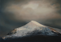
Rùm, the largest of The Small Isles, has a population of only about 20 or so people, all of whom live in the village of Kinloch on the east coast and work for Scottish Heritage or similar. Kinloch is at the head of Loch Scresort, the main anchorage. The Sound of Arisaig separates the Arisaig peninsula to the north from the Moidart peninsula to the south. There are a number of small islands in the sound, the largest of which is Eilean nan Gobhar and Samalaman Island. See Rùm photo of below ...


28th July – Arisaig to Loch Nevis: Past Loch Moidart – which Richard described as a hard entrance - we continued up past Loch Ailort and then past Mallaig, into Loch Nevis and moored at the visitor’s mooring at ‘The Old Forge’ at Inverie at Knoydart, which, with no roads in or out, either an 18 mile hike over Munros or a 7 mile sea crossing, this pub claims to be the remotest on mainland Britain. I couldn’t have mussels as a starter – Richard had Stalkers Salad and we both had Lobster for a main course – but thought it a bit tough.


John and Janet Trythall – Contessa 32 owners – came aboard and I found out she was a retired anesthetist and he was a retired physics and outdoor teacher at Gordonstoun. Their Contessa is called Jaywalker – CO 9910C and they are from Elgin.

29th July – Loch Nevis to Loch Hourn: A short cruise (about 18 nM) but to the wildest (and wettest) loch I had anchored in … thus far.

30th July – Loch Hourn to Plockton: Left the Loch but the excitement was to come – up through the Kyle Rhea, the strait splitting Skye from the mainland. A ferry service (now March to October only) has linked Kylerhea with Glenelg on the mainland for centuries. We shot up through with me at the helm and Richard telling me to concentrate as we did 7+ knots or so. We broke out into Loch Alsh in windy conditions and sailed up to see (from a distance) in Loch Duich the castle Eilean Donan. We then turned and had lunch tied up at Kyle of Lochalsh.

After lunch we past the sight - in the distance – of Raasay and Scalpay and near to, (once we had past under the Skye Bridge), Longay and Eilean Mor (and Eilean Meadhonach). We had Applecross on our port as we sailed up Loch Carron. We moored in Plockton (on John & Janet Trythall’s mooring). Had a shower at Heathers … very welcome though Richard wasn’t bothered! I waited for him – at the wrong pontoon apparently – I was pretty cold when he turned up!


31st July – Plockton to Doune Bay: Back under the Skye Bridge and down through Loch Alsh and through the Kylerhea at 2pm… we made a stop at Richard’s reckoning at Doune Bay (he thought Mallaig would be noisy).


This is when the electrics failed on us! I had a restless night too, having to get up when the mooring buoy wrapped around the mooring rope and clanged on the hull … twice! I finally sorted it at about 1:30 in the morning.

1st August – Doune Bay to Oronsay’s Loch na Droma Buidhe: Richard woke me at something before 6 am wanting us to get off and round Ardnamurchan Point having heard about the foul weather coming in. We got to Tobermory in pouring rain and bad wind only to be told that because of West Highland Week we couldn’t be accommodated … so we sailed/motored across a stormy sea to Loch na Droma Buidhe and anchored at the top of the bay in about 20 metres! Though she swung a lot, the boat always turned to face the anchoring point, even if it was just before it turned completely.

2nd August - Loch na Droma Buidhe to Tobermory: We had a very late start in spite of being up reasonably early as Richard thought it mad to go out in bad wind. I watched some windsurfing from a cutter anchored near us for a while whilst Richard read below. After lunch, at about 2.30 we set off. Once we were at the top of the Sound it seemed really rough and confused so we went into Tobermory and got a pontoon (much to Richard’s disgust probably!) - though the electrics came back once we had shore-power(?). We ate a fish & chip takeaway, after a coffee and replenishing our milk and bread at the Coop.

3rd August – Tobermory to Dunstaffnage: A windy, wet but brilliant sail down the Sound and across out of the Firth of Lorne - out across Ardmucknish Bay to Dunstaffnage. Got in at about 3:30 having set off at about 9:30 at Tobermory.


The Highland Midge


The Highland midge (Culicoides impunctatus) - or Midgie or in the gaelic Meanbh-chuileag - is a species of small flying insect found in upland and lowland areas (fens, bogs and marshes) especially in the north west of Scotland from late spring to late summer. Female Highland midges are well known for gathering in clouds and biting humans,


and are the smallest flies in Scotland to do so, though the majority of the blood they obtain comes from cattle, sheep and deer. They are generally regarded as pests.


Despite Scotland's exceptionally cold winter in the early part of 2010, scientists discovered that after the prolonged freezing conditions, rather than reducing in number actually increased the following summer due to the cold weather reducing its natural predators, such as bats and birds. The female midges tend to bite in close proximity to the breeding site (although they have been found up to 1 km away) and near to the ground, and are most active just before sunset. Midges are less active after sunset, as well as with wind speeds of over 6 mph, or humidity below 60-75%.

Tuesday, 23 July 2013

2013 June - second sail of the season with Stan & Jane

Stan & Jane came up and stayed the night of the 10th June. Margaret and I had a meal in with them and then, the next day on the Tuesday Stan & Jane plus myself set off North in their car.

We got to Dunstaffnage at around 4pm where I got the keys and we transferred all the relevant gear to the boat, which seemed in good nick. We did a shop at the Coop in Oban at around 6pm and then had dinner in Room 9 Restaurant and turned in when we got back after a drink in the Wide Mouthed Frog.

On the Wednesday we motored out and sailed across to Loch Etive to stay the night at the new Pontoon/Shower Block.
Walked to the Ardtornish Estate


Thursday saw us sailing up the Sound of Mull to Tobermory, where we stayed two nights, one full day. On the first night we ate on board - really nice .... The next day we spent going around the area of Tobermory - for example the Mull Museum in Tobermory crams a great deal of information into a very small space. They could have a room three times the size and it would still be full. ... We also strolled around the front, buying some beer at the Coop. Stan bought a fishing rod set and we went to the Ferry terminal. Then we went up to 'An Tobar' to have lunch and saw Fred Schley's painting exhibition and Sam Jones' photography exhibition.


Then a lazy afternoon sorting out some sail issues with the genoa, and at night we went to see "Why Do You Stand There in the Rain?" at the Mull Theatre is based at Druimfin, just outside Tobermory. The play is about the "Bonus Army," who, 80 years before the current "Occupy movement," marched on Washington DC. WWI vets, as part of compensation for war wages, were promised bonus compensation when they died or retired. Hundreds of thousands of veterans were out of work during the depression. They asked the government 'give our bonus to us now.' There were protests. In 1932 they occupied Washington D.C. Veterans and their families built a Hoover town. They called it the 'Bonus Army.' It was just like the occupy movement. In the end, the military was called in, and the protesters were cleared out by troops commanded by Generals Douglas MacArthur and George Patton. A cavalry charge, followed by troops armed with fixed bayonets and canisters of adamsite gas-an arsenic-based tear gas-were used to disperse the protesters, while spectators reportedly called "shame,shame! According to newspaper reports, approximately 10,000 men, women and children took part in the Bonus Army protest, 55 were injured and 135 arrested. A 12-month-old baby allegedly died from tear gas exposure and a woman miscarried. The Senate defeated the bill that would have allocated the bonus funds to the veterans by a vote of 62 to 18. The play was excellent!


Displays include the geology of the island; prehistory including Standing Stones, Duns and Brochs; the visit of Johnson and Boswell; the wreck of a Spanish galleon from the Armada fleet; the arrival of a ship from Newfoundland which had been blown off course across the Atlantic; the planned development of Tobermory in the nineteenth century as a fishing port; crafting, farming and other trades; the village school, etc.

On the Saturday we sailed across to Salen in Loch Sunart.

On the Sunday we came back down the Sound after motoring out of the loch and sailed to Dunstaffnage (though we motored the last bit).

On Stan's 60th we had to motor to Port Appin

Back to Dunstaffnage and stayed the night - then tidied up on the Monday and left at 11:00ish an got home at 4:30ish and then after some time at home wnet to Westbourne Spice for a curry. Stan & Jane left next morning.

Sunday, 23 June 2013

2013 season - 28th May to 2nd June - finished at the Corran Narrows!

Richard and I went up to Dunstaffnage - setting off from Ilkley at 11ish and arriving there at about 5pm. Got the keys and had a disappointing dinner at Oyster Inn which claims to have views over Loch Etive, to Mull, some of Lismore and Morven but I couldn't see much!

Slept on the boat as we were going to set off earlish (8am!) but realised that the halliards were poorly organised and so waited until Rob and one other had sorted them next morning. Pushed off about 2pm - couldn't reef as Ramshead was upside down (!) and got into Loch Spelve at about 4pm to anchor in the South West arm. Dropped the hook and made sure we were fast at about 5pm and then had pasta/bolognaise and a beer. Turned in reasonably early.


Next day we up anchored, (the hook had got caught in an old mooring rope) and set off back across the Firth. We had a great sail and after a false steer, we were heading up the Sound of Kerrera looking for our next anchorage ... the castle shaped hill misled Richard ... it was too tall for the one he was looking for, we found our way and motored


gently went into Phuilladobhrain (pronounced Pol dor an, meaning Pool of the Otter in English) for the night. We were sharing this with maybe six or seven other boats when along came another five or so .... luckily some were Drascombes and took up little room. The most worry aspect was dragging anchors, too big an anchoring circle and boats adrift - happened at least once, with an old chap shouting across to me that he was Jeremy Roger's Brother-in-Law - just as his brig was about to crash into a sloop!

Richard took the tender and rowed up the Pool to see if he knew the guys in the Drascombes.


When he came back we left the boat for dinner at the Tigh na Truish Inn. After using the tender to get ashore and following the shore line path we went up the path, over the small hill to first take in the views from the legendary


"Bridge Over The Atlantic" .... built in 1792 by John Stevenson - a man of the Oban area: the rare Fairy Foxglove (Erinus alpinus) covers the bridge in a gentle purple haze in the early summer, further enhancing an already beautiful structure. (Innish faces you as you cross the "Bridge over the Atlantic Ocean" on to the Isle of Seil).


Tigh na Truish Inn (The House of Trousers - after the Jacobite Risings when kilts were banned, the islanders were reputed to change out of their kilts and into trews here, when going the mainland). The footpath taken going back (same a going) has views over the Firth of Lorne to Mull, Kerrera, Lismore and other small islands, with Morven in the far distance.


The next morning I readied the boat as Richard did a voyage plan - got the dinghy aboard and deflated / tucked away ... and sorted out the halliards etc. (Didn't realise it but reefs not tied off at the clew ). We pulled up the anchor - pretty easily though she had bedded well in mud - and motored gently out the Pool. Whilst Richard sorted out the sails I took the helm and then we switched off the engine and sailed for a good few hours. I spent a bit of time following up on what Richard had started - cleaning the mud off the deck. We decided to take advantage of a broad reach and sail up the Firth of Lorn, Lynn of Lorn and into Loch Linnhe, through the Corran Narrows and aiming at Fort William.

The Corran Ferry links the main A82 road with Morvern, Moidart and Ardnamurchan, via the village of Strontian. It also provides a link to Lochaline, thirty miles to the south west, from where a ferry crosses to Mull.


Close to the western slipway are Corran Lighthouse and the Ardgour Inn. The route lies on one of the ancient drove routes from the Hebrides to the cattle markets in Central Scotland.

We anchored (!) in a bay called Inverscaddle Bay. Though we tried (twice) to get a solid anchor bite we ate (!) and looked upon the South-East side of Ben Nevis which still had snow on some of the slopes. After worrying about the anchor we upped hook having decided that we were not happy ... so at about 11:30pm we motored back to Dunstaffnage and got in at about 4am. Moored up with slip lines etc. and then slept at 4:30 through til around 9ish.

Friday, 29 March 2013

PassagePlus

PassagePlus


PassagePlus is a passage planning, navigation and ship tracking application aimed at the leisure sailing market. To the best of my knowledge it is the only Mac OS X application compatible with the UK Hydrographic Office's ARCS charts.

Menu

* Display chart

* Display GPS position of your boat on chart (if GPS is connected)

* Display related data, e.g. COG, SOG, DTW, etc.

* Display AIS data as an overlay on the chart (if AIS receiver is connected)

* Import/create and store way-points

* Import/create and store routes

* Show track (assuming GPS is connected), save it, export it (for printing, etc)

* Shows bearings and distances between points on chart

* Dead reckoning and three-point fixes without a GPS

* Shapes a course to steer allowing for leeway and tide

* Projects position forward based on current course and speed

* Automatically creates a log if GPS is connected

Stern Glands

Stern Glands

The conventional stern gland is usually part of the inboard shaft bearing assembly and its sole job is to keep the water out whilst allowing the shaft to turn. They fall into two main types:-

- "PATENT" TYPES" - These do not need packing, are supposed to last for "life". They often have a telltale bottle. There are a number of designs like Deep Sea Seals & Carbon ring seal. Will they seal if the shaft is bent? Dunno....

Some modern, non-packed, stern glands have an oil bottle attached by a short hose. This is NOT FOR LUBRICATION - it is a telltale - in case the gland starts to leak and shows up by either loss of oil or water appearing in the oil.

- "PACKED TYPES" - In this type (the vast majority), the shaft disappears either through a large, longish nut, or through a sleeve which is held in place by two nuts/bolts. These glands have a "tacky" rope like material inside them which is squeezed up by the big nut or sleeve to stop leaks.


Packing Stern Glands
- First of all you must recognise that there are many different types of non-packed stern glands being fitted today and if one of these is leaking you may well be faced with taking the boat out of the water and either pulling back or totally removing the propeller shaft. Some packed glands are associated with a "rubber hose" as part of the assembly, so the fact that there is "rubber" present cannot be taken as any of indication of gland type.

Locating leaks. If a boat is taking water from the general area of the stern gland many people's first reaction is to tighten the gland, however there are other things that should be checked. Clean the black "gunge" from the face of the gland and inspect the hole from which the shaft emerges. If the shaft is not leaving the gland concentrically with the hole and gland (as shown on the right) the gland is worn and may never stop leaking for any length of time. On boats with flexible engine mounts this is often because the rubber mounts have collapsed with age and the engine has not been re-aligned with the shaft every few years. If the mounts collapse on a GRP boat and the situation is ignored the shaft can wear right through the bronze shaft log. This creates a leak (with a sharp edged to the hole) at point Y. Likewise if the rubber hose on this gland is not checked for condition it can perish and leak. If it splits there is a good chance that the boat will sink. If you have an adjustable gland a slight bow in the shaft or even an engine "jumping about a bit" can cause the ball joint to work loose and then the O rings get damaged and the joint leaks.

Adjusting the gland.
Convention has it that a gland should drip between once and twice a minute, and if you have a "yellow metal" shaft this is vital to prevent unacceptable shaft wear. However if you leave your boat for long periods you have to rely upon an automatic bilge pump, rely upon a film of grease to keep the gland watertight, or tighten the gland before leaving the boat and slacken it for running. To carry out the adjustment slacken any lock nuts and then tighten the adjusting nut until the gland drips as you require. On glands like Fig 1 please ensure that you tighten the nuts each side of the gland evenly. Remember to re-tighten the lock nut(s) when you have done. Never adjust so far there is no more adjustment left for a later occasion, if you do the gland will leak and you will be unable to stop it. When you have about 12mm (half an inch) of adjustment left it is probably time to think about re-packing the gland.

Preparation for packing.
Having decided that it is now time to pack the gland you must first of all consider how much wear you found when you inspected the front of the gland. The greater the visible wear the more worn the bearing surfaces are likely to be and thus the greater volume of water is likely to leak in when the packing has been removed. If the gland has a remote greaser (as most canal boats) tightening this down may well stop almost all leaking. If you are concerned about the amount of water that may leak in on a narrowboat you can remove the weed hatch and wrap cling-film or mastic bandage into the space between propeller and back of boat - but please remember to remove it before putting the boat in gear!

Removing the old packing.
Some people simply add more packing on top of what is already there. This may be fine in an emergency, but the old packing will have lost a lot of its "body" and is likely to be hard and worn. It is best to repack from scratch, so you need to get all the old packing out. If you bought a pre-pack you may find instructions inside telling you to buy a special removing tool. Remove the nuts and any "pusher" and screw the screw into the old packing (Fig 11). Then use pliers on the screw head to pull the screw and old packing out. Repeat until you can feel the screw scraping on bare metal. Now the water may be jetting in, but it will be at low volume. This is where you will be grateful that you prepared the packing before taking the old stuff out! You have lots of time - so don't panic.

Repacking the gland. Conventionally, take a piece of packing and push it down the hole using a blunt instrument (I had a length of mahogany I kept for the purpose, but nowadays I use a screwdriver). Note the position of the cut/join. Put the next length in with the cut about 120 degrees away from the first one. Repeat for the next length and so on. Do not totally fill or overfill the void. If you do you will have problems getting the parts back together and may well cross thread the big nut or jamb the pusher. Leave at least 3mm of space above the top packing ring. The leak should now have virtually stopped. Unconventionally, wrap the packing around the shaft in the direction noted before and just keep pushing it fully home, one bit at a time. Note, with this method the gland may leak a bit in reverse.

Adjusting the gland.
If the gland is still leaking gradually tighten the nut(s), turning the shaft with your hand* until the drip either just stops or drips once or twice a minute. Now you can pump out the bilge and double check that all lock nuts are in place and tight. Run the engine in ahead and astern for half an hour or so. Keep checking for leaks and adjusting (with engine stopped) as required. Take the boat for a run. Keep feeling the gland for overheating and checking for leaks. Adjust if required.

Packless glands
. Certain packless glands utilise a rubber boot on the shaft that holds a ring seal against the face of the stern tube. As with any "rubber" component one must take care to ensure it is changed as soon as there are signs of the "rubber" deteriorating. Certain types are designed so you can fit two onto the shaft. A working one and a back up one some way up the shaft. If the working one fails you can cut it off and then fit the spare in its place without taking the boat from the water. The gland must be adjusted whenever it starts to drip to excess. They are supposed to drip about once every minute or so, but privately owned boats which spend a lot of time out of use would either sink or flatten their batteries via the automatic bilge pump. Most private boats would adjust the gland by tightening the big nut/sleeve until the drip just about stops, the stern tube greaser is then used to finally seal the drip at night and when the boat is left. If the nut/sleeve is fully tight or if the gland will not stop leaking, the gland needs re-packing. If the engine has dropped or been misaligned the gland and bearing may well be worn egg shaped. This will prevent the packing sealing, or, more likely, cause the packing to be shredded inside the gland. Always carefully inspect the bore of a gland which will not stop leaking to make sure it is not worn

The Greaser. This is often referred to as the stern GLAND greaser but, in fact, it actually lubricates the inboard shaft bearing and in boats with plain outboard bearing, that also. Whatever type of greaser you have fitted your lecturer would NOT ADVISE the use of "water pump grease" especially if you have a plain outboard bearing. This grease is too thick and is difficult to get into the bearing. Plain outboard bearings use the grease or emulsion of grease and water passing down the stern tube for lubrication, so ensure they get an adequate supply. Rubber (cutless) outboard bearings should be grease resistant, but you I would not put them to the test. With this type of bearing be more sparing with the stern gland greaser.

Shaft alignment - This topic follows stern glands and shaft logs because, as already stated, an out of alignment shaft will cause bearings and glands to wear, and thus leak. They also cause overheating of the gland and bearing and excess vibration and noise. The easiest way to avoid these problems altogether is to use a suitable flexible coupling so the engine and shaft does not have to be aligned.

Flexible Couplings. There are three types of flexible couplings:

1. Anti-torsional vibration couplings - these are characterised by some form of rubber inserts and are quite stiff, in fact they are usually impossible to bend by hand. They MIGHT allow a small amount of angular misalignment, but all one can be sure of is that they smooth out the torque from the engine and cushion the engine from anything which tries to stop the prop. This type of coupling should be aligned.
2. One piece flexible couplings - this type allows a limited amount of angular and radial (vertical/horizontal) misalignment. They are more flexible than type one. "Centaflex" typifies this type. Never exceed the amount of misalignment quoted by the manufacturer. The gearbox and shaft should be initially aligned with this type AND checked every year. A solid dummy coupling is often used to replace the flexible coupling whilst aligning the shaft.

3. Flexible "jack shaft" types - typified by "Aquadrive" or intermediate shafts containing a pair of vehicle universal joints. These is the only "fit and forget" couplings as far as alignment is concerned. They might need greasing regularly (if they are U.J. types I would insist they have a grease nipple fitted). They will require a thrust block to transfer prop thrust to the hull, otherwise they will "dog leg". The thrust block might be part of the assembly (Aquadrive), otherwise the thrust block will also need regular lubrication. These types allow the use of very flexible engine mounts if required.

Aligning the shaft - This is a very bad name - you actually align the engine. It is far easier to demonstrate the procedure than to explain it in text. First, loosen the stern gland so the shaft can be slid back and forth, then remove the bolts holding the half couplings together (fit dummy coupling if required). Slide the shaft back so the male "land" come free from its recess. The shaft will now "flop about" to a greater or lesser extent - much greater if you have a flexible shaft log. Using scrap block of wood pack the shaft so it will still slide, but is held centralised within the free play. Slide the shaft forward until the couplings meet. The land should slide into its recess. If it does not the shaft is out of radial alignment. This engine needs lowering to align the couplings. The engine might also have to be moved sideways on its beds to cure radial misalignment.

Next use feeler gauges all round the gap in the couplings to check the angular alignment. To cure this misalignment the front of the engine has to be raised, but in doing this the gearbox coupling will move down, so the engine will also have to be lifted. This procedure of raising and lowering various parts of the engine will eventually bring the shaft into alignment. Try and get the gap to less than 0.1mm. Slide the shaft forwards, it should slide home easily, recheck with feeler gauges. Check tightness of engine mounts and recheck alignment. Bolt up couplings and tighten stern gland.

Raising & lowering the engine. Some engines are supported on long, threaded studs between two nuts. These are the easiest to raise and lower, they are also the most likely to drop when the nuts work loose. Another method is to use a pair of (metal I hope) wedges under each foot which are slid over each other to raise or lower the engine. These can slide out by vibration and cause the engine to drop. The traditional way is to cut shims from scrap metal shaped like a square U. The engine mounts are loosened and the engine levered up. The shim is slid in place with the open end pointing downhill (towards the stern). These work well but the engine needs tightening every time a shim is inserted to ensure it is absolutely flat.

Tide and time wait for no man ...

Tide and time wait for no man ...

An introduction, some definitions and refreshers

Chart datum is the reference level above which heights of tide are predicted and below which charted depths are measured. The datum used for most British ports is the lowest sea level predicted under average meteorological conditions for that port - unlike the land mapping datum for the ordinance survey which is fixed for the whole U.K. and is based on mean sea level (see footnote).

Range is important for tidal barrages and is the difference in height between successive High and Low waters.

Tides arise from the gravitational pull of the moon and sun on the major oceans of the world. The biggest tides occur when the sun, moon and earth are on the same axis and are called spring tides and occur about every two weeks. In the intervening week the sun - world - moon axis become at right angles -
resulting in a reduced gravitational pull on the oceans. These tides are known as neap tides and the range is about 64% of the spring range. In the Bristol Channel spring tides occur in the evening and early morning and neaps at midday and midnight.

Tidal predictions are for average conditions and in practice can be affected by meteorological conditions such as atmospheric pressure and gales.

So why are tides in some locations much higher/lower than the general levels? The main reason is the shore configuration e.g. the coast of South Wales and England together with the shelving sea bottom. The narrowing and shelving would not affect the level if the rate of rise was very slow but for the momentum of the thousands of tons of water entering at speeds up to 4 or 5 knots. Other effects occur in long closed estuaries and channels which have a natural wave resonance period which when coinciding with the tidal period gives a large amplification of the tide.

Together with changes in tidal heights come tidal currents or tidal streams. Off Portishead streams reach 4.8 knots at springs and 2.6 knots at neap tides. Near Lynmouth on the N.Devon coast, streams reach 4 and 1.9 knots.

The establishment of a UK Tide Gauge Network* (UKTGN) was recommended as a result of severe flooding along the east coast of England in 1953 and it is now owned and funded by the Environment Agency (EA).

*part of the National Tidal & Sea Level Facility which is hosted by the National Oceanography Centre (NOC) - a consortium consisting of NOC science groups, the British Oceanographic Data Centre (BODC) as well as the UK Tide Gauge Inspectorate.

The network comprises 45 gauges - related through the national levelling network to Ordnance Datum Newlyn.


Definitions:
Chart Datum (CD)
CD is the reference level from which heights of tide are predicted and charted depths are measured. In the UK it normally approximates to LAT, and the tide will not frequently fall below it. The actual depth of water in any particular position is the charted depth plus the height of tide.

Lowest Astronomical Tide (LAT)
LAT is the lowest level which can be predicted under average meteorological, and any combination of astronomical, conditions. This level will not be reached every year. Storm surges can cause even lower levels to be reached.

Highest Astronomical Tide (HAT)

HAT is the highest level which can be predicted to occur under average meteorological conditions and under any combination of astronomical conditions, except storm surges. It is the level above which vertical clearances under bridges and power lines are measured; see 4.5.

Ordnance Datum (Newlyn)
Ordnance Datum (Newlyn) is the datum of the land levelling system on mainland England, Scotland and Wales, and to which all features on UK land maps are referred. The difference between Ordnance Datum (Newlyn) and CD is shown at the foot of each page of tide tables in this Almanac. Differences between CD and foreign land levelling datums are similarly quoted.

Charted depth
Charted depths are printed on charts in metres and decimetres (0.1m) and show the depth of water below CD. (Not to be confused with a sounding which is the actual depth of water (charted depth + height of tide) in a particular position.)

Drying height
A drying height is the height above CD of any feature which at times is covered by water. The figures, in metres and decimetres, are underlined on the chart. The depth of water over a drying feature is the height of tide minus the drying height. If the result is negative, then the feature is uncovered at that time.

Vertical clearances
Under bridges and power lines - these are measured above HAT. Some older charts may still show clearances above MHWS; see 4.5.

Elevation of lights
The charted height of a light (its elevation) is measured above MHWS.

Height of tide
The height of the tide is the vertical distance of the sea level above (or very occasionally below) CD. Predicted heights are given in metres and decimetres.

Rise/Fall of tide

The Rise of the tide is the amount the tide has risen since the earlier Low Water. The Fall of a tide is the amount the tide has fallen since the last High Water.

Duration
Duration is the time between LW and the next HW, normally slightly more than six hours. It can be used to find the approximate time of LW when only the time of HW is known.

Interval
The interval is a period of time quoted in hours and minutes before (–) or after (+) HW. Intervals are printed in hourly increments (–6hrs to +6hrs) along the bottom of each tidal curve diagram in Chapter 9.

Spring tides

Spring tides occur roughly every 16 days, near to Full and New Moon, when the tide–raising forces of Sun and Moon are at a maximum. See 4.9 for phases of the Moon.

Neap tides
Neaps occur roughly every 16 days, near the Moon's first and last quarters, when the tide–raising forces of Sun and Moon are at a minimum. See phases of the Moon.

Mean High Water and Low Water Springs/Neaps
MHWS and MHWN are the means of predicted HW heights of Sp or Np tides over a period of 18.6 years. Similarly, MLWS and MLWN are the means of LW heights for Sp and Np tides respectively. Mean tide level (MTL) is the mean of the above values.

Mean Sea Level (MSL or ML)
This is the average level of the sea's surface over a long period, preferably 18.6 years.

Range
The range of a tide is the difference between the heights of successive HWs and LWs. Spring range is the difference between MHWS and MLWS, and Neap range is the difference between MHWN and MLWN.

Standard Ports
have tidal characteristics observed over a long period and are suitable as a reference for secondary ports on the adjacent coasts.

Secondary Ports

Have similar tidal characteristics to those of their Standard Port. Time and height differences are applied to the Standard Port predictions. 'Secondary' does not imply lesser importance.

Tidal Coefficients
Indicate the range of a tide. Daily values are listed and explained in 9.0.9.

Tidal definitions


Footnote: In Great Britain, Ordnance Datum (OD) for the Ordnance Survey is ODN (Ordnance Datum Newlyn), defined as the MSL at Newlyn in Cornwall.